
Real Estate Aerial Photography & Videography
Elevate Your Listings: Aerial Photography & Videography for Real Estate Excellence
In today's competitive real estate market, aerial photography has become an essential tool for both residential and commercial listings.
With stunning aerial perspectives, you can showcase properties in a way that captivates potential buyers and highlights the unique features of each listing. From attracting qualified buyers to maximizing a home's market appeal, aerial photography offers a comprehensive view that traditional methods simply cannot match. Let MorLo Aerial Imaging elevate your real estate assets by providing breathtaking imagery that engages clients and makes a lasting impression. Discover how our aerial photography services can enhance your listings and drive success in your sales.
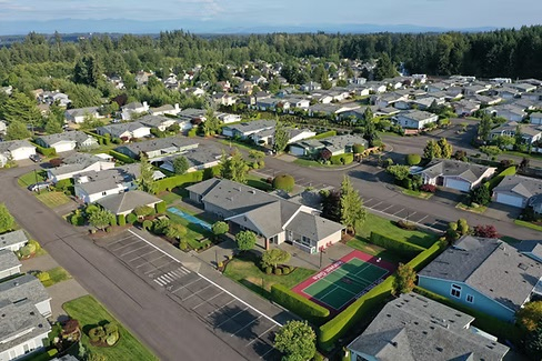
RESIDENTIAL REAL ESTATE
Aerial photography & Videography is no longer a luxury, it's a necessity to spotlight your real estate listings:
Showcase your listings from the best available perspectives.
Attract the most qualified buyers for your listings.
Make a lasting impression of your properties.
Maximize your home's appeal on the market

COMMERCIAL REAL ESTATE
Photography & Videography at its highest potential:
Engage your clients with breathtaking perspectives.
Showcase your office building and surrounding points of interest.
Highlight close proximity to highway access and local shopping centers.
Show off the full allure of the surrounding landscape.

Ultimate Property Marketing Package: Reality Capture & Aerial Imaging
Elevate your property marketing with our comprehensive package combining cutting-edge Reality Capture technology, stunning 3D LiDAR scans and, incredible aerial drone photography.
Package includes:
- Virtual Tour- Immerse potential buyers with an interactive experience
- Interior & Exterior Images- High-quality photos showcasing every aspect of your property.
- Drone/Aerial photography- capture breathtaking aerial views, highlighting your property’s landscape and surroundings.
- Dedicated property website- A professional online presence to showcase your property.
- 1-Year of website hosting- Hassle-free hosting to ensure your property remains accessible.
Prices starting as low as $450 for up to 3,000 Sq. Ft. with everything included above. Let us help you stand out in the market with our premium 3D LiDAR scanning and aerial photography solutions!
Contact Us Today!
Elevate your mapping projects with our aerial services.